
| Welcome to South Bristol Views - a short history of South Bristol, NY. This text was supplied by our Town Hall, a group of very friendly and helpful people. Any typo's that may be present would be my fault of course ;-) |
 |
|
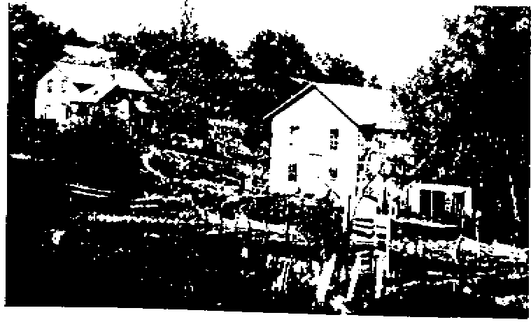
The Town of South Bristol is situated in the Bristol Hills of Ontario County South of the City of Rochester, and includes all of Lot No. 8, Range 4, and part of Lot No. , Range 3 (of the Phelps and Gorham Purchase Map of 1790) with Canandaigua Lake as the Eastern boundary. Prior to settlement, there was a fairly large Indian population occupying several villages between Bristol Springs, what is now County Road 34, and along the lake shore. These sites and several large orchards, with the exception of the orchard on Seneca Point, were all destroyed by General Sullivan in 1779. In 1788 Gamiliel Wilder purchased the township from Phelps and Gorham. The following year they moved with family and friends from Connecticut to the site of the Old Indian Orchard on Seneca Point. Vestiges of the orchard were still evident until the last remaining tree was removed in 1915- 127 years later. During 1790, a road was cut over Stid Hill from Seneca Point, and a settlement was established near what is now the intersection of New York State Route 64 and County Route 34. During 1791, the road was extended beyond Boswell's Corners, over Frost Hill to Briggs Gully, where Wilder had built a sawmill. Politically, the town remained a part of Bristol until March, 1838, at which time it was set off and separately organized. The site of the first Town Meeting, Allen Brown's tavern, continued to serve as the Town's meeting place for many years. Large tracts of land were cleared for farms and orchards. Later with the growing population of surrounding areas, the need for lumber brought about the clear cutting of vast areas of the Bristol Hills which in turn resulted in rapid erosion of much of the rich, alluvial soil. Over the ensuing years, many sawmills were erected. The B.T. Hawkins sawmill, pictured here [above], was still in operation well after the turn of the century. Although more conservatively harvested, timber remains one of the Town's important resources. Sheep were raised in abundance, in the early days. Key agricultural crops were hops and berries. Most of the berry dry-houses, which are still in existence, were built for raspberries, and much of the raspberry crop was sold to the Jello Company of Leroy, New York. Portions of the berry crops were also used for dyeing fabrics. In the late Nineteenth century, general farming gave way to the vineyards, which remain the principal agricultural activity of the Town. The forests slowly returned restoring the natural beauty of the once denuded hills. At the same time Canandaigua Lake began developing as a Summer retreat for Rochester city folk with hotels and numerous cottages being built along the shore. With the exception of the heavily developed lake shore, South Bristol remains rural, and a year round haven for outdoor enthusiasts of all persuasions. Thanks for visiting South Bristol Views and let us know what you think! |
|
For more historical and geneological information about South Bristol and Ontario County, see these links:
| Ontario County Records & Archives |
| Town of Bristol web site / history |
| Ontario County NY Gen Web |
| Ontario County Historical Society |
| Ontario County History, books etc. |
Note: All photographs, pictures and artwork displayed on this site are copyright © 2001 South Bristol Views. Any reproduction or other use by written consent only!
To get around our site, just click on one of the menu items above.
Entire site contents
© 1999-2015 South Bristol Views